TL;DR
Smappen’s Free UK Postcode Mapping Tool
- Free and User-Friendly: Smappen offers an intuitive platform for creating UK postcode maps.
- Strategic Business Applications: Utilize Smappen to define catchment areas, optimize delivery or sales zones, planning franchise territories with precision.
- Data-Driven Insights: Enhance decision-making by overlaying demographic data, analyzing competition, and exporting postcode information.
Understanding your market’s geography is paramount. Having a clear visual of your operational areas can make all the difference. Enter Smappen— free, user-friendly tool designed to help you create detailed UK postcode maps (districts and sectors), enabling smarter decisions and strategic planning.
Postcode Mapping: Create and Manage Business Areas
Postcodes in the UK aren’t just for mail delivery; they represent specific geographic areas that can be leveraged for various business applications.
By mapping these postcodes, businesses can:
- Identify Target Markets: Understand where potential customers reside.
- Optimize Logistics: Plan efficient delivery routes and service areas.
- Strategize Marketing Efforts: Tailor campaigns to specific regions.
- Plan Franchise Expansions: Determine ideal locations for new outlets.
Examples
- Retail Expansion: A clothing retailer can identify underserved areas by mapping postcodes and analyzing population density.
- Delivery Services: A food delivery company can optimize routes by visualizing service areas within specific postcodes.
- Franchise Planning: A coffee shop chain can plan new outlets by analyzing competition and customer demographics in targeted postcodes.
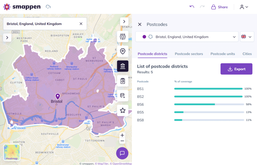
Using Smappen to Create UK Postcodes Maps

Here’s an example on the Smappen app: creating a Bristol postcode map.
Getting Started with Smappen
Creating a UK postcode map with Smappen is straightforward:
- Access the Platform: Visit Smappen’s website and sign up for a free account.
- Add an Area: Click on “Add an area” in the left panel.
- Choose Map Type: Select “Territory” and opt for “Postcode districts” or “Postcode sectors” based on your desired level of detail. Here’s how to do it
- Define Your Area: Click on the map to select specific postcodes or use the search bar to find them.
- Analyze and Export: Once your area is defined, you can analyze demographic data, assess competition, and export postcode lists for further use.
Benefits of Using Smappen
- User-Friendly Interface: No GIS expertise required.
- Customizable Maps: Tailor maps to your specific needs.
- Data Integration: Overlay demographic and business data for deeper insights.
- Collaboration Tools: Share maps with team members or stakeholders.
- Export Capabilities: Download postcode lists for marketing or logistical purposes.
Visualise, Don’t Just Search: Smappen Is Not Your Average Postcode Finder
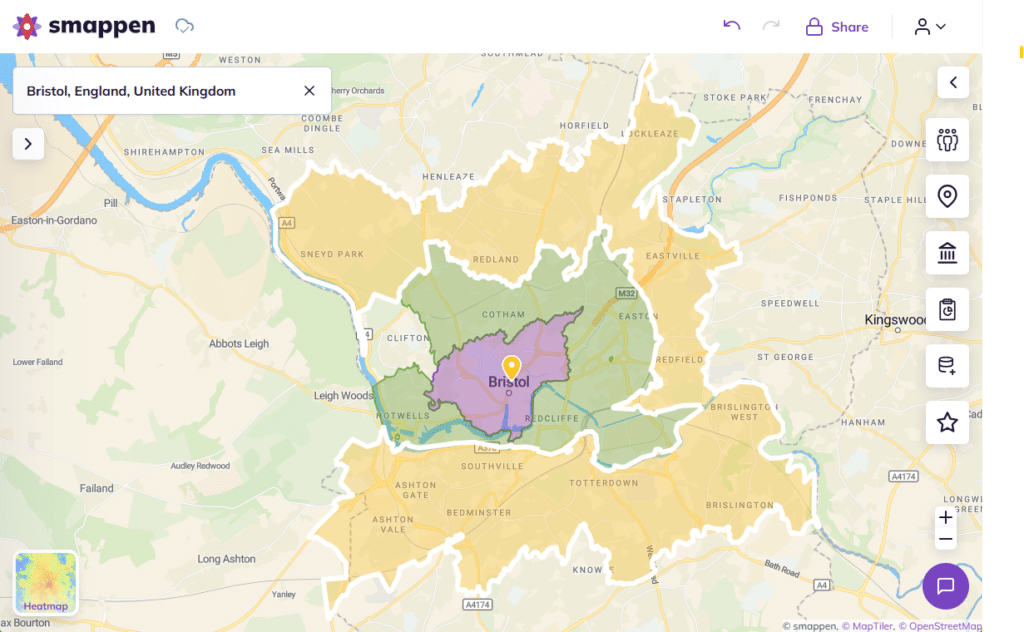
Let’s clear the air—Smappen isn’t your run-of-the-mill postcode finder. You won’t be typing in a code to get a quick address lookup. Nope, Smappen does something way cooler. It lets you visualise postcodes directly on an interactive UK map.
Imagine seeing entire postcode districts or sectors light up before your eyes—perfect for planning, strategizing, or simply getting a clearer picture of where your business is making moves.
Whether you’re defining delivery zones, sketching out sales territories, or plotting your next store launch, Smappen turns boring old postcode data into vibrant, usable maps. It’s not about finding a postcode—it’s about seeing it in action
Advanced Tips to Empower your Postcode Map
So, you’ve got the basics down—drawing postcode areas and visualising your territory. But what if you want to go pro? Here are some next-level tricks to get the most out of your Smappen postcode maps:
Custom Colours for Clarity
Assign colours to postcode areas based on performance metrics—like sales volume, delivery frequency or charges, or customer density. This visual cue makes it ridiculously easy to spot trends and areas needing attention at a glance.
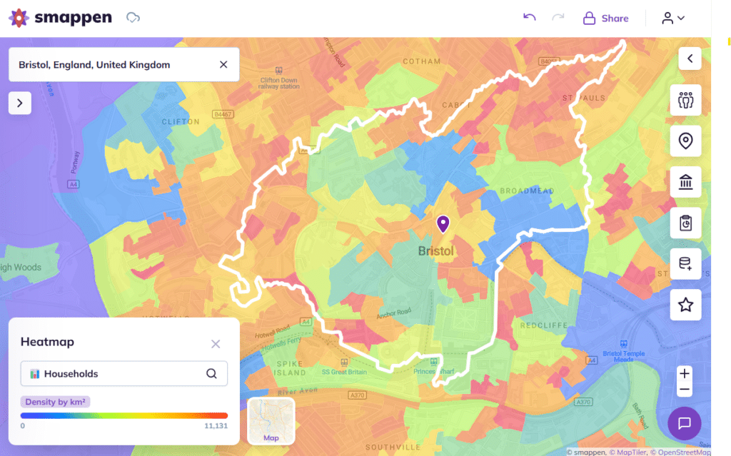
Turn Up the Heat: Using Heatmaps to Spot Opportunities
Smappen’s heatmap feature shows you where your business potential is sizzling and where it’s ice cold. By transforming postcode areas into colour-coded heat zones, you can instantly spot high-density areas, customer clusters, or delivery hotbeds.
By creating detailed UK postcode maps, you can make informed decisions that drive growth, efficiency, and customer satisfaction with Smappen. Whether you’re looking to expand your market reach, optimize operations, or launch targeted campaigns, Smappen provides the tools you need—all for free.
Frequently Asked Questions (FAQs)
Yes, Smappen offers a free plan that provides access to its core features, including postcode mapping.
Absolutely. Once you’ve defined your area, you can export the list of postcodes for use in marketing campaigns, logistics planning, and more.
Yes, Smappen allows you to overlay demographic information, helping you understand the population characteristics within your defined areas.
Indeed. Smappen offers collaboration tools, enabling you to share maps and insights with team members or stakeholders.
Definitely. Smappen is designed to be user-friendly and accessible, making it ideal for businesses of all sizes looking to leverage geographic data for strategic planning.