
Isochrone Map
Draw Free Isochrone on a Map with Smappen
Looking for a map generator or travel time map calculator? Draw isochrone map and travel time for free with Smappen!
Isochrone Map Generator: Draw and Analyze Drive-Time Areas in One Click
Plan smarter, faster, and fairer territories!
With Smappen, you can instantly create isochrone maps (drive-time areas) to understand how far your customers, franchisees, or teams can reach — in minutes.
👉 No GIS skills needed. Just click, visualize, and analyze.
What Is an Isochrone (Drive-Time) Map?
An isochrone map shows how far you can travel from a point within a given time — for example, 10, 20, or 30 minutes by car.
It’s one of the simplest and most powerful tools to analyze accessibility, coverage, and performance in your business network.
Use it to:
-
Identify your real catchment area
-
Compare locations based on travel time rather than distance
-
Plan fair and balanced territories for your franchisees
-
Spot overlaps or gaps between your territories
Key Features of Isochrone Maps
Time Intervals: they typically display multiple time intervals to show different levels of accessibility.
Mode of Transport: these maps can be customized for walking, cycling, driving, or public transport.
Dynamic Data Integration: modern ones can integrate real-time data, such as current traffic conditions.
What is the difference between Isodistance and Isochrone?
While both isochrone and iso distance maps are used to measure accessibility, they do so in different ways. Isochrone maps consider real-world factors like traffic and transport modes, whereas isodistance maps measure straight-line distance.
Isochrone Maps represent areas accessible within the same amount of time from a specific point. They are useful for analyzing travel times, public transport efficiency, and service accessibility. Example: Showing areas within a 30-minute drive from a city center, considering traffic conditions and road types.
Isodistance Maps represent areas within a specific distance from a central point, regardless of travel time. They are more useful for studying spatial relationships and proximity without considering travel dynamics. Example: Showing areas within a 5-mile radius from a store location, ignoring variations in travel speed or obstacles.
How to Make Isochrone and Travel Time Map?
Creating an isochrone map involves several steps:
- Select a Point of Origin: choose the starting location for your analysis.
- Gather Data: collect data on travel times using various modes of transportation. This can include traffic data, public transport points and schedules, and walking paths.
- Use Mapping Software: utilize GIS (Geographic Information System) software or online tools like OpenRouteService, or Mapbox to generate the isochrone map.
- Define Time Intervals: set the time intervals you want to display on your map (e.g., 10, 20, 30 minutes).
- Generate the Map: use the software to create the isochrone map, highlighting areas accessible within the specified time frames.
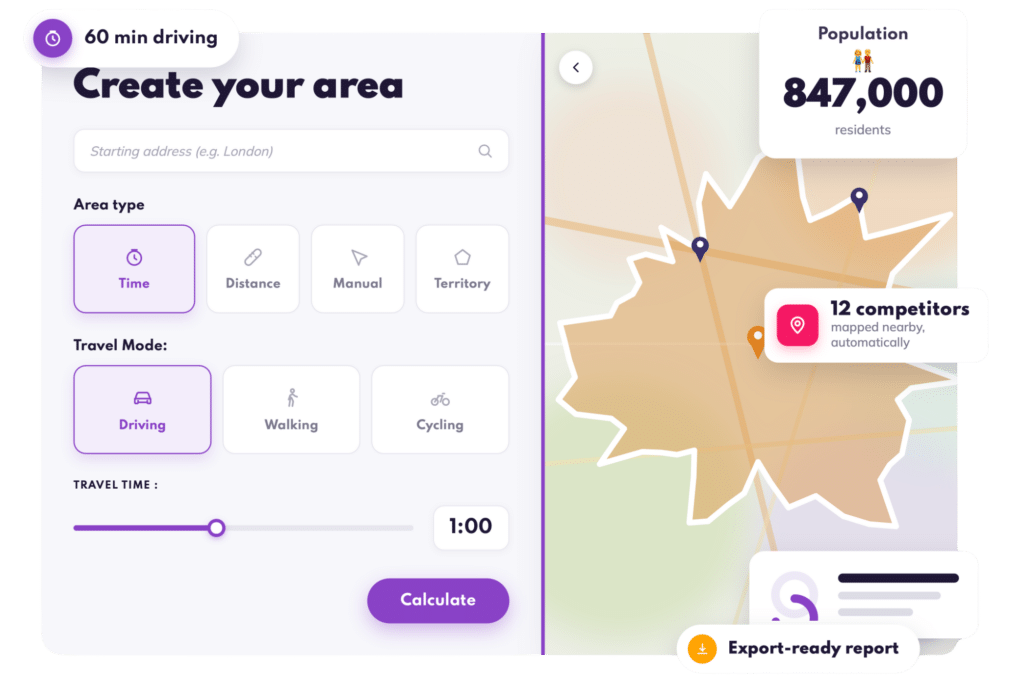
How It Works with Smappen
-
Choose a starting point (an address, postcode, or store).
-
Select travel mode (drive, walk, bike).
-
Set your time limits (e.g. 10, 20, 30 minutes).
-
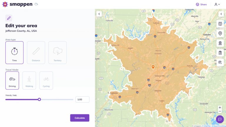
Smappen instantly draws the isochrone area on the map.
-
Analyze data inside the area — demographics, businesses, services, and more.
✅ Save, export, or compare areas in seconds.
✅ Combine multiple zones to detect overlaps or potential cannibalization.
✅ Integrate your data from HubSpot or CSV files.
What are the Interests of Isochrone Maps?
Using Isochrone Maps for Business Development & Sales Territories
They are incredibly useful for a variety of applications.
Isochrone maps are incredibly valuable for business development and sales territory planning because they provide a clear, visual way to understand geographic reach based on travel time rather than just distance. This leads to better customer targeting, sales efficiency, and operational strategy.
For example, planners use isochrone maps for urban planning, to assess the accessibility of services, optimize public transportation routes, and ensure equitable access to amenities. These maps help identify underserved areas and improve infrastructure planning.
They also are essential for emergency services, helping determine the fastest routes for emergency vehicles. This ensures improved response times and better resource allocation.
And many more if you add some data in the equation!
What About Drive-Time Analysis
For franchisors and network developers, travel-time areas are key to:
- Ensuring fair and profitable territories
- Supporting franchisees with data-based performance zones
- Avoiding overlaps and internal competition
- Accelerating expansion with clear, visual territories
For retailers and sales teams:
- Identify new store opportunities
- Optimize sales routes and coverage
-
Measure customer accessibility to each site
“Smappen made it so easy to define balanced territories for our franchisees — and the data is spot-on.”
— Mark Holland, Body Street UK 🇬🇧
Use-cases
Businesses can analyze potential markets by understanding how far customers are willing to travel. These maps help identify lucrative locations for expansion.
Assess competitor locations and their accessibility, identifying opportunities for new locations. This helps gain a competitive edge in the market.
🧩 Franchise Development
Design fair franchise territories based on real drive-times, not arbitrary distances.
➡️ Example: a franchise reduced territory overlaps by 28 % using Smappen’s drive-time areas.
🏬 Retail Expansion
Compare different potential store locations and pick the one with the largest 20-min coverage area.
🚗 Sales Performance
Define and balance your sales reps’ zones based on realistic travel times.
Explore Data Inside Each Isochrone
Inside each drive-time area, Smappen lets you analyze:
- Demographics (population, households, income, etc.)
- Points of Interest (POIs): competitors, services, businesses
- Custom data (import your KPIs or CRM data)
- Heatmaps to visualize opportunities or density
Everything you need to turn maps into actionable insights.
Travel time maps are powerful tools that provide valuable insights across various fields, from urban planning and emergency services to business strategy and geomarketing. By understanding and utilizing isochrone maps, you can make informed decisions that enhance accessibility, optimize resource allocation, and improve service delivery. Whether you’re a business owner, franchisor, urban planner, or marketer, these maps can significantly contribute to achieving your goals.
Try It Yourself or Book a Demo
Create your first isochrone map in less than 1 minute.
No installation, no GIS training — just clear, powerful data.
Frequently Asked Questions (FAQ) about Isochrone
Tools like Google Maps API, OpenRouteService, and Mapbox are commonly used. GIS software like ArcGIS and QGIS also offer robust capabilities. But Smappen is the best one 😉
The accuracy depends on the quality of the input data, including traffic patterns, public transport schedules, and walking paths. High-quality, up-to-date data ensures greater accuracy.
Yes, they can be generated for different modes of transportation, including walking and cycling, providing valuable insights for urban planning and recreational purposes.
Yes, there are free tools available, you can try Smappen for free to create unlimited isochrone maps.
Create your isochrone map with Smappen