Territory Mapping
How to Design Smarter Territories for Your Network
Whether you’re carving out your first 10 franchise territories or rebalancing a sales team’s coverage, the way you draw the map decides who succeeds and who struggles. This guide covers what territory mapping is, how to do it well, what it looks like in the US, UK, Canada, and Australia, and which tools to use, with real examples from franchise networks that got it right.
Key takeaways:
- Territory mapping is the process of dividing a geographic market into defined areas — by zip code, county, drive time, or radius — and assigning each one to a franchisee, rep, or location.
- For franchisors, territory boundaries are disclosed in Item 12 of the FDD; the franchise agreement defines whether a territory is protected, exclusive, or open.
- Strong territories are sized on market potential (population, income, target customers), not surface area.
- The most common failure mode is territory overlap, which leads to cannibalization and franchisee disputes.
- With Smappen, you can draw, analyze, and assign territories the day you sign up — no GIS expertise required.
What is Territory Mapping?
Territory mapping involves creating visual representations of geographical areas to allocate resources, manage franchise and sales regions, and plan strategic expansions.
Far from being just a pretty map, it’s a powerful strategic tool.
Done well, it helps you:
- Maximize market coverage
- Balance workloads and opportunities
- Avoid cannibalization between territories
- Unlock data-backed insights about your performance
And when done with Smappen? It’s fast, visual, collaborative.
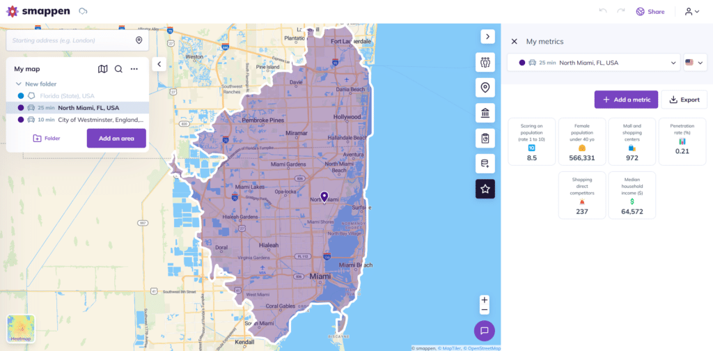
Benefits of Territory Mapping Software
See Your Whole Network at a Glance
A live map replaces the spreadsheet of zip codes nobody can picture. Sold territories, open territories, white space, and overlap — all visible in one view you can share with your team, your candidates, and your brokers.
Enhanced Strategic Planning
Mapping software allows for precise visualization of market areas, helping businesses identify opportunities and challenges within specific regions. This insight is invaluable for strategic planning and resource allocation.
Improved Sales Management
By clearly defining sales territories, you can ensure balanced workloads among sales teams, prevent overlaps, and optimize customer coverage. This leads to increased productivity and customer satisfaction.
Data-Driven Decision Making
Collect relevant data such as customer locations, sales figures, and demographic information. Make informed decisions based on real-time information, leading to better outcomes and reduced risks.
Why Invest in Territory Mapping?
Whether you manage a franchise network, a multi-site business, or a growing sales team, territory mapping plays a key role in:
- Ensuring each rep or location has fair and realistic goals
- Aligning field efforts with real-world market potential
- Planning growth with full visibility on white space
- Supporting high-stakes decisions like renewals, relocations, or buyouts
Sales Mapping vs. Territory Optimization
Let’s make one thing clear: not all mapping is strategic.
Basic mapping is often static: just drawing shapes around postcodes or ZIPs.
Territory optimization adds real intelligence: balancing workloads, segmenting opportunities, analyzing performance.
With Smappen, you get both:
✔️ Intuitive tools to draw and edit territories
📊 Real data to evaluate and improve them
🧠 Smart features to identify overlaps, gaps, and areas of opportunity
Choosing the Right Territory Mapping Software
When selecting a software, consider the following features:
- User-Friendly Interface: Ensure the software is intuitive and easy to navigate.
- Customization Options: Look for tools that allow for tailored maps to fit your specific business needs.
- Data Integration: The ability to integrate various data sources enhances the depth of analysis.
- Scalability: Choose software that can grow with your business.
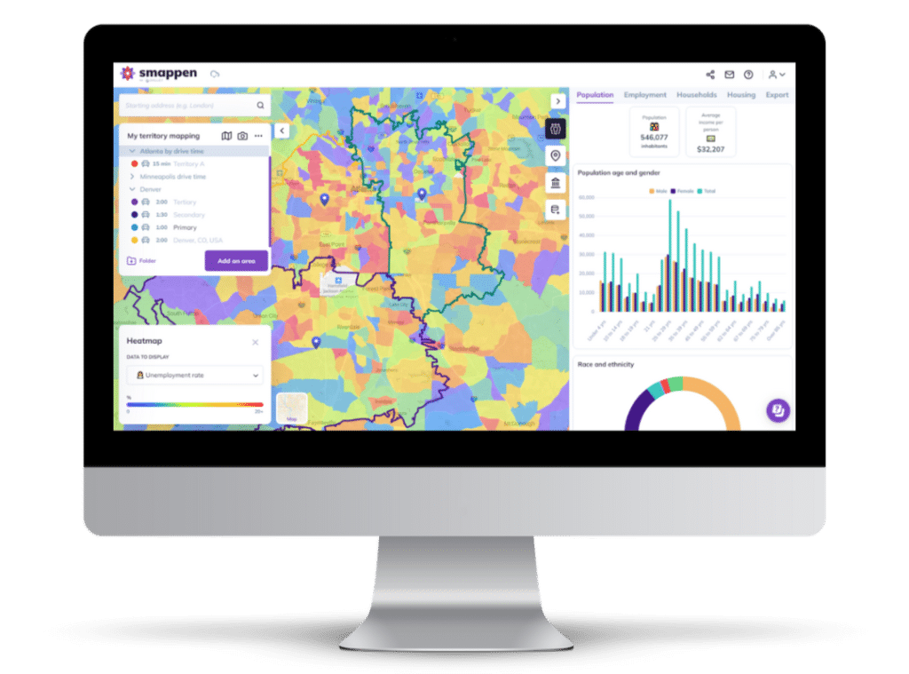
Smappen: Simplifying Territory Mapping for Businesses
Smappen is a user-friendly mapping software designed to help businesses visualize and manage their geographical areas effectively. With its intuitive interface, users can easily create, edit, and analyze territories without the need for technical expertise.
The tool offers features such as customizable maps, real-time data integration, and collaborative tools, making it ideal for business owners and franchisors looking to optimize their operations and drive growth.
> That’s how One Source Moving Solutions went from improvised boundaries to a repeatable territory model — read how they build bulletproof franchise territories with Smappen.
Examples of franchise territories by country
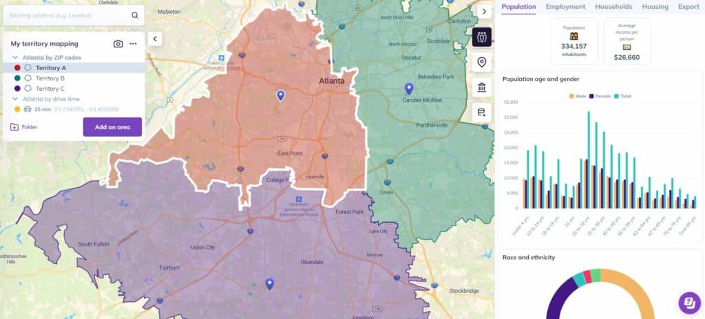
United States – ZIP Code Territories
In the U.S., franchise and sales territories are often defined by ZIP codes. With Smappen, you can:
- Visualize areas by ZIP, city, or county
- Analyze by population, income, or customer locations
- Identify territory overlap between franchisees
Ideal for retail, food, and home services networks.
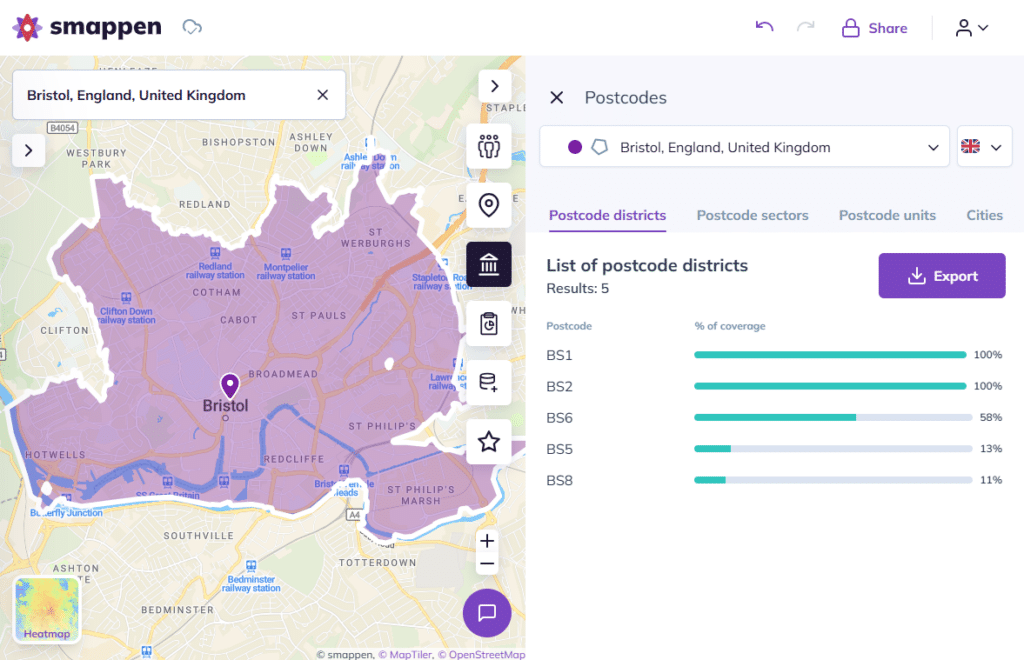
United Kingdom – Postcode Sectors
In the UK, territory management often relies on outward codes (e.g. SW1, EC2). Smappen helps:
- Combine postcode sectors into custom regions
- Track penetration rate and customer reach
- Map competition proximity
Works great for healthcare, education, and property networks.
Canada – Postal Code Precision
In Canada, mapping with FSA (first 3 digits of the postal code) allows:
- Urban vs rural territory segmentation
- Smart coverage in bilingual or multicultural areas
- Optimization by drive-time (a key in vast provinces)
Perfect for service franchises and B2B field teams.
Australia – Drive-Time Over Distance
In Australia, distance is misleading: a 20 km territory in Sydney and a 200 km territory in regional Queensland can carry the same workload. Australian networks map with:
- Postcodes, suburbs, or LGAs as building blocks
- Drive-time zones that account for real road networks
- ABS demographic data to validate each territory’s potential
Well suited to mobile services, home care, and fitness franchises.
See our guide: Travel Time vs Distance: Planning Business Reach in Australia.
Territory Mapping and the FDD: Protected, Exclusive, or Open?
A franchise territory is only as strong as the agreement behind it. In the US, Item 12 of the Franchise Disclosure Document (FDD) is where a franchisor describes the territorial rights a franchisee receives — and under the FTC Franchise Rule, if no exclusive territory is granted, the FDD must say so explicitly.
In practice, most networks choose between three models:
- Protected territory — the franchisor won’t open or license another unit inside the boundary. The most common promise, and the one that demands precise, defensible boundaries.
- Exclusive territory — stronger: the franchisor also won’t sell through competing channels (online, alternative formats) inside the area.
- Open (non-exclusive) territory — the franchisee operates from a location with no boundary protection at all.
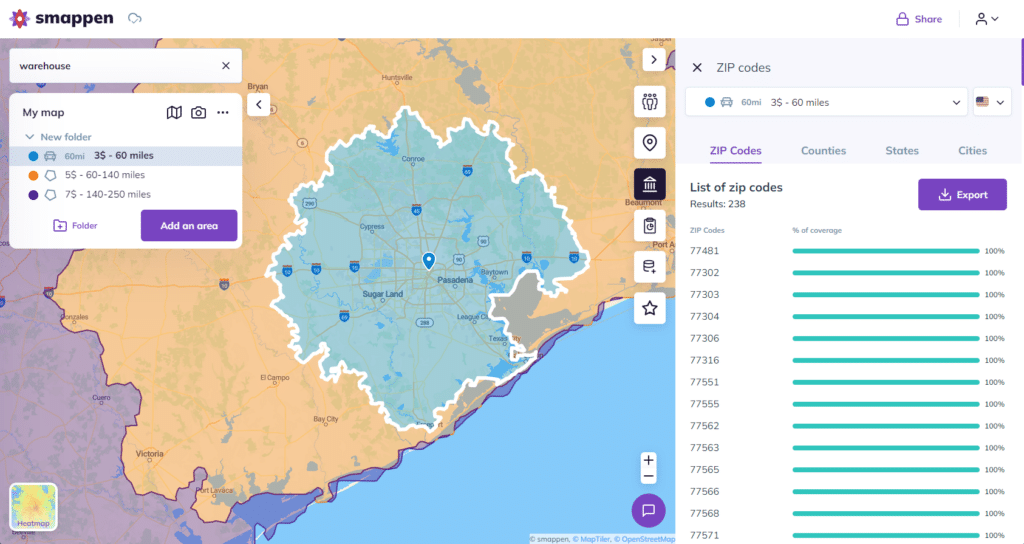
Whatever the model, the map is the contract exhibit. Vague boundaries (“the greater Phoenix area”) create disputes; a precise list of zip codes or a drive-time polygon doesn’t. With Smappen, you can export the exact zip code list for each territory and attach it to the agreement — so the legal description and the map can’t drift apart.
5 Territory Mapping Mistakes to Avoid
- Sizing on surface area instead of potential. A territory’s value is its market, not its square mileage. Two territories of identical size can differ 10x in opportunity.
- Using fixed radiuses everywhere. A 10-mile circle means something completely different in downtown Chicago and rural Nebraska. Drive-time zones reflect how customers actually move.
- Granting territories too big, too early. Oversized early territories lock up your best markets and starve future development. You can’t easily take territory back. Not sure where to start? Here’s the right size for a franchise territory.
- Ignoring overlap until it’s a dispute. Cannibalization rarely announces itself — it shows up as two franchisees fighting over the same customers. Check overlap at design time, not at renewal time.
- Mapping once and never revisiting. Markets shift. Review territories every 6–12 months against actual performance data.
We wrote a full breakdown with examples: 6 Common Mistakes in Designing Franchise Territories.
Best Practices & Key Metrics
🧠 Top tips:
- Base your territories on real potential, not just surface area
- Adjust regularly: every 6–12 months or before each campaign
- Cross-check with customer data and sales figures
📊 Monitor these KPIs:
- Coverage rate vs market size
- Revenue per territory
- Client density vs effort
- Overlap / white space
Recommended Tools
| Tool | Strengths | Best for |
|---|---|---|
| Smappen | Self-serve, visual, built-in demographic data, fair pricing | Franchises and growing businesses |
| Maptitude | Deep GIS analysis, steeper learning curve (compare) | GIS/analyst-heavy organizations |
| Salesforce Maps | Native CRM integration | Enterprise sales teams on Salesforce |
| Maptive | Google Maps-based visualization | General-purpose mapping |
| MapBusinessOnline | ZIP-based territory drawing | Basic SMB territory routing |
Ready to Map Smarter?
No matter where your team is — or where you’re expanding — Smappen helps you map smarter, faster, and with more impact.
+1200 customers & franchises chose Smappen


Read our best articles on the topic
Territory Mapping: Strategies for Sales and Franchise Growth
Explore the power of territory mapping – a game-changing approach for optimizing sales performance and franchise expansion.
Answering your questions
What is territory mapping?
Territory mapping is the process of visualizing and organizing geographical areas for business purposes like sales, service coverage, or franchise development. It’s crucial because it helps balance workloads, identify new market opportunities, and streamline operations — all of which can boost profitability and customer satisfaction.
How does territory mapping software help franchisors and business owners?
Mapping tools give franchisors and business owners the power to create clear, data-backed territorial boundaries. This ensures franchisees don’t step on each other’s toes, while making expansion easier and more strategic. It’s like giving your business GPS for growth.
What are the benefits of territory mapping?
Improved sales performance
Enhanced customer satisfaction: Efficient territory management ensures timely service and support, leading to improved customer relationships.
Cost efficiency: Reduces travel time and expenses by optimizing routes and minimizing redundant efforts.
Data-driven decisions: Utilizes geographic and demographic data to make informed decisions about market strategies and resource allocation.
Scalability
How to create a territory map online?
Creating a territory map online involves several steps:
Choose a mapping tool: Select a reliable territory mapping tool like Smappen that offers the features you need.
Import data: Upload relevant data, including customer locations, sales data, and other key metrics.
Define criteria: Establish the criteria for dividing territories, such as geographic boundaries, population density, or sales potential.
Draw boundaries: Use the tool to draw and adjust territory boundaries based on your criteria.
Assign resources: Allocate sales teams, service personnel, or other resources to each territory.
Analyze and optimize: Use the tool’s analytics features to assess the performance of each territory and make necessary adjustments.
Implement and monitor: Roll out the territory plan and continuously monitor performance to ensure it meets your business objectives.
What is an example of a franchise territory?
Consider a national fast-food franchise expanding into a new region. The franchise territory might be defined by the following factors:
Geographic boundaries: Major highways or natural barriers like rivers that delineate the area.
Population density: Urban areas with higher population densities are given priority to maximize customer reach.
Competitor locations: Areas are selected to minimize direct competition with existing franchises.
Demographic data: Target demographics, such as age groups and income levels, are analyzed to choose the most promising locations.
Accessibility: Easy access for both customers and delivery logistics is considered.
Manage your territories with Smappen
The most intuitive territory mapping app on the market. Create your areas, sort them easily, and assign them. Use built-in demographic data or import your own to assess each territory’s potential.