TL;DR
UK Postcode Structure: The UK’s postcode system is divided into areas, districts, and sectors, which helps in accurately segmenting markets for business development and logistics optimization. This system consists of 124 areas, 2,979 districts, and about 1.8 million individual units.
Creating a Postcode Map with Smappen: Smappen provides a user-friendly platform for businesses to create detailed maps based on postcodes, which can aid in strategic decision-making. This process involves selecting specific postcode districts or sectors and integrating demographic data for advanced market research and competitive analysis.
Strategic Application of Postcode Data: Through detailed postcode maps, businesses can conduct thorough market research, perform competitive analysis, and optimize coverage areas to ensure maximum market penetration and operational efficiency.
In the wild world of business development and network expansion, knowing your postcodes isn’t just a nice-to-have—it’s absolutely essential. These little alphanumeric codes do much more than ensure mail delivery; they are fundamental tools for segmenting markets, optimizing logistics, and defining franchise territories.
How do UK postcodes work?
The United Kingdom is divided up into 124 postcode areas. These are split into 2,979 districts, further split into 2,979 districts, 11,232 sectors, and approximately 1.8 million individual units. That’s a considerable number of postcodes!
According to the Postal Museum, the United Kingdom began trialing postcodes in 1959 in Norwich. Following further trials during the 1960s, the system was rolled out nationwide, designed to streamline mail delivery and assist in local and regional planning.
Understanding Postcode Areas, Districts, and Sectors
Let’s decode the structure of UK postcodes to better understand how they can serve your business needs:
Postcode Areas
These broad geographic markers consist of one or two letters, like “L” for Liverpool or “RH” for Redhill. Recognizing these areas can help you identify major regional markets.
Postcode Districts
Each area contains several districts, indicated by numbers following the area letters (e.g., “L1”, “RH1”). These districts offer a more refined segmentation, useful for local marketing strategies and logistics planning.
Postcode Sectors
Adding a further layer of granularity, sectors are marked by a digit after a space (e.g., “L1 8”, “RH1 4”). Utilizing sector data can enhance local service delivery and operational efficiency, essential for managing a network of franchises or business locations.
Examples of UK postcodes
To demonstrate, here are some examples of how postcodes break down:
L1 8JQ: in this Liverpool postcode, “L” identifies the area, “1” pinpoints the district, “8” indicates the sector, and “JQ” specifies the exact location.
RH10 1GE: here, “RH” is the Redhill area, “10” identifies the district, “1” the sector, and “GE” the precise location
The case of London postcodes:
London is so big that several postcode areas were needed! They can be identified by their initial letters which typically relate to compass directions or notable zones within the city:
- E (East London)
- W (West London)
- N (North London)
- SE (South East London)
- SW (South West London)
- WC (Western Central London)
- EC (Eastern Central London)
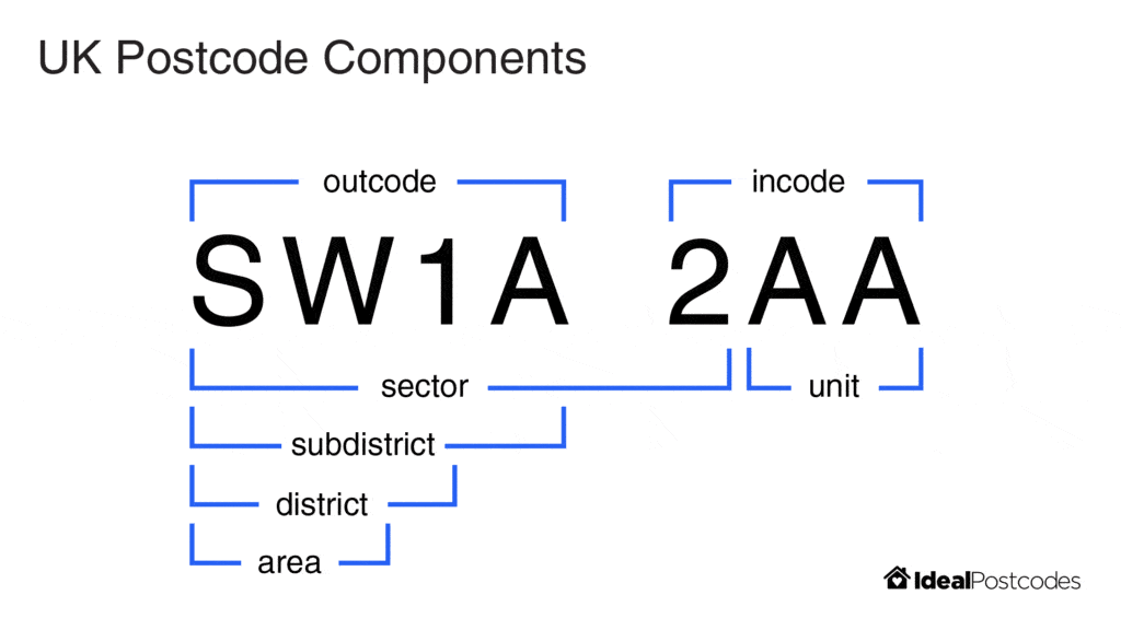
Then each area is made up of several districts which often correspond to specific neighborhoods or boroughs within London. For instance, “SW1A” covers Whitehall and Buckingham Palace, or “E1” includes areas like Whitechapel, Stepney, Spitalfields. And finally, sectors add a further level of detail, indicated a specific locality within the district which can be a street or a part of the neighborhood like “SW1A 0” that covers areas around the Houses of Parliament.
Let’s take the example of SW1A 2AA: “SW” identifies South West London, “1” pinpoints the district, “A” the subdistrict, “2” indicates the sector, and “AA” specifies the exact location. The current address of this postcode is 10 Downing Street (yes the Prime Minister’s house!)
How to build your UK postcode area map?
For franchisors, network founders, and business developers, creating a detailed map of your areas based on postcodes can significantly enhance strategic decision-making. Smappen provides a powerful, user-friendly platform for this purpose.
Create your catchment areas based on postcodes
With Smappen, you can create areas based on postcode districts or sectors in Wales, Scotland and England.
Let’s take a practical example: Imagine you’re at the helm of a burgeoning fast-food company that’s ready to expand across London. Here’s how you could use Smappen to effectively map and analyze your catchment areas:
Get started: log into Smappen and navigate to the ‘Add an area’ option in the left panel
Choose your map type: from the Territory list, choose a map focused on postcode districts, or sectors, depending on the level of detail you need. For a fast-food chain, it might be most effective to zoom in to the sector level to understand consumer density and local competition better.
Draw your area: select your aimed districts or sectors in London directly on the map to add to your catchment area. For this fast-food brand, targeting the sectors around a train station like Kings Cross could be interesting (for example the following London postcodes: N1 9, N1C 4, NC1H 8, and NC1H 9).

Analyze your catchment areas
You now get your area, that’s great! But it’s even greater to be able to analyze it and get valuable insights to inform strategic decisions.
Analyzing your catchment areas through Smappen can transform how you approach market research, competitive analysis, and optimizing coverage areas:
Market research
Combine demographic data with your postcode maps to explore potential markets. Understanding variables like income levels, educational attainment, and demographic profiles linked to specific postcodes can provide a substantial competitive edge in targeting marketing efforts.
Competitive analysis
For businesses with significant competition, mapping software allows you to cross-reference publicly available data about your competitors with your own mapping insights. This strategic use of data helps identify competitive hotspots and areas where market penetration could be increased.
Optimizing coverage areas
For sales and service-oriented businesses, using Smappen to define and adjust territories ensures comprehensive market coverage without overlap, maximizing efficiency and profitability. This ensures that your team is optimally deployed to cover as much ground as possible, enhancing service delivery and sales reach.
In conclusion, creating UK postcode map with Smappen is more than just plotting geographic data—it’s a strategic undertaking that enhances your operational capabilities, enriches your market understanding, and sharpens your competitive edge. As you expand your business or franchise network, embracing the power of postcode-based mapping with Smappen could be a game-changer, providing you with the insights needed to make informed decisions and achieve sustainable growth.
FAQ (Frequently Asked Questions)
A UK postcode is an alphanumeric code used by Royal Mail to designate geographic areas throughout the United Kingdom. Each postcode typically consists of two parts: an outward code that identifies a broad area, and an inward code that pinpoints specific addresses or clusters of addresses. This system is essential for efficient mail delivery and provides valuable data for geographic and demographic analyses.
A UK postcode map is a visual tool that displays the geographic boundaries defined by postal codes across the United Kingdom. It helps users understand local demographics, analyze market distribution, and plan location-based strategies for businesses and personal needs.
A UK postcode map provides valuable insights into where your customers or target audience are located. It’s ideal for:
- Evaluating potential business locations.
- Planning targeted marketing campaigns.
- Analyzing local market penetration and demographic distribution. In short, it helps you make data‑driven decisions based on geographic and population trends.
Creating a UK postcode map on Smappen is easy:
- Enter your target postcode or address into our interactive tool.
- Click “Draw” to select each postcode you need to generate an accurate, interactive map that outlines the postcode area and relevant demographic insights.
- You can also set your desired parameters—such as travel time or fixed distance—to define the area. And then transform your area into postcode one (or simply extract list of postcodes into your area).
There are approximately 1.7 million unique postcode units in the United Kingdom. This extensive network ensures that every address is accurately located, supporting not only effective mail delivery but also detailed geographic research and market analysis.