While the term “geospatial data” might sound like it’s straight out of a sci-fi movie, it’s actually a critical component of many services you rely on every day. Whether you’re searching for the best restaurant or navigating zoning laws for a new construction project, you’re using geospatial data. Let’s dive into this fascinating world, explore its uses, and understand the different forms it can take.
What is geospatial data?
Geospatial data can be simply defined as information that’s related to a location somewhere on Earth — or even in near orbit! This type of data is integral to many location-based services you use daily, from driving directions to real estate listings.
Geospatial data can come from a variety of sources, including databases, maps, and satellites. Common examples include GPS coordinates and addresses, but timestamps, categorizations, and other types of information can also be classified as geospatial data as long as they are linked to a location.
Why is geospatial data so important?
Geospatial data provides context in a way that humans intuitively understand. Time and space are the main metrics we use to comprehend and measure the physical world. By turning space into data points, geospatial data feeds various technologies and projects, making it a unique and invaluable resource.
Geospatial data collection and sources
Collecting spatial data involves various methods, including satellite imagery, aerial surveys, and ground-based observations. Key sources of geospatial data include:
National Geospatial Programs: Like the United States Geological Survey (USGS) and Federal Geographic Data Committee (FGDC).
GIS Data: Geographic Information Systems (GIS) databases provide a wealth of geospatial information for analysis and decision-making.
Open Data Platforms: Many governments and organizations provide access to public geospatial datasets.
Geospatial Data Tools and Technologies
To make the most out of spatial data, several tools and technologies are available:
Geographic Information Systems (GIS): Powerful systems for storing, analyzing, and visualizing geospatial data.
Remote Sensing: Uses satellite or aerial imagery to collect data about the Earth’s surface.
GPS Technology: Provides precise location data, essential for mapping and navigation.
Data Management Systems: Tools for storing and organizing large datasets, ensuring data quality and accessibility.
What type of data do geospatial technologies provide?
Geospatial technologies, such as Geographic Information Systems (GIS), offer a wide range of data linked to locations on Earth. Here are some common types:
GPS coordinates
When you think of geospatial data, GPS coordinates are likely the first example that comes to mind. These numeric data points represent specific locations, such as the Hollywood Sign in Los Angeles (34.134117, -118.321495) or the summit of Mount Everest (27.987850, 86.925026).
Addresses
Local addresses are another common example of geospatial data. Whether you’re finding the nearest gas station or planning a sales route, you’ll be using applications full of address data.
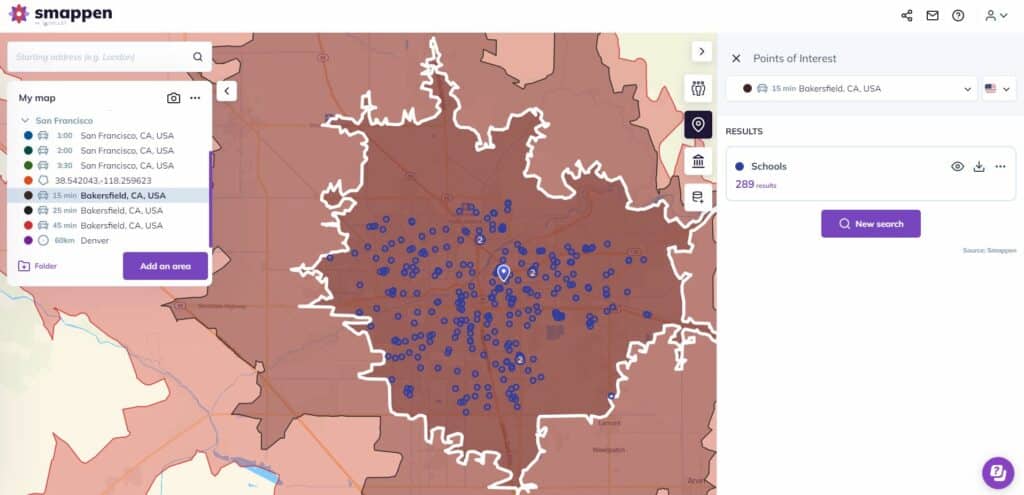
Points of interest
Points of interest are physical locations that someone might find intriguing. For a tourist, this could be a restaurant or hotel, while for a lawyer, it might be a police station or courthouse. The location data associated with these places is a type of spatial data.
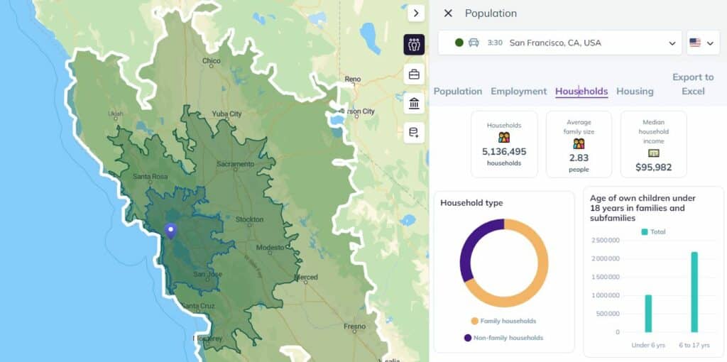
Property
Property data attempts to represent the physical bounds of property as accurately as possible. Whether it’s for physical buildings or land, this data is often represented on a map, usually to help plan various projects or settle disputes.
Boundaries
Geospatial data also includes administrative, judicial, and national boundaries. These boundaries represent agreed-upon divisions rather than physical locations, yet they are crucial for various planning and legal purposes.
What is geospatial data used for?
Geospatial data serves as the backbone for various projects and technologies. Here are just a few examples of how spatial data can be used.
Making maps
This seems like the most obvious application, right? Since spatial data deals with locations on Earth, it makes sense that you’d use it to make maps. You could use GPS information to create satellite imagery or addresses to draw neighborhood maps, for example.
Site selection
Whether you’re dealing with real estate, municipal projects, or business strategy, site selection is essential. Otherwise, that new condo building might not get tenants, that community center might stay empty, or that new store could get shut down soon after opening. Geospatial data is essential for picking the best possible location for these projects.
Visit attribution
Visit attribution is used by businesses to get more information about the people who visit their stores using mobile data. Because geospatial data can include GPS data from mobile phones, it’s used by marketers and sales teams to tailor their strategy as they figure out who their ideal customers are.
Urban planning
Whether they’re planning road maintenance, new urban projects, or new services, municipalities use geospatial data to isolate the needs of their population and plan the best way to meet those needs. That can mean finding the best location for a new building or using population data to determine where services are most urgently needed.
Telecommunications network planning
Telecommunication companies have some of the most massive infrastructure projects in the world, and keeping them running depends on a ton of geospatial data. Have you ever had to report an internet outage to your service provider? Then you’ve used geospatial data. But it doesn’t stop there. Everything from planning the construction of a new cell tower to sharing a coverage map with customers depends on geospatial data.
Investment research
Hedge and private equity funds typically do a ton of research before adding an investment to their portfolio. While some of that research involves diving into publicly available financial information, geospatial data is important, too. Investors want to know where a company is located, local market conditions, and any local risks that could influence its value.
Business strategy
Location-based information is critical for working out a business strategy. Business owners need to know where their potential customers live and where they spend their money. They need to know as much as possible about the local area and its competitors.
Risk assessment
Risk assessment is a discipline that’s all about identifying, mitigating, and resolving the potential risks associated with all kinds of endeavors, from construction to business and government services. A foreman might use geospatial data to ensure that their crew won’t be drilling into a gas line, while a risk assessor working for an investment fund might use similar data to determine local risks to a new business.
Give it some space
Geospatial data is so essential to so many processes that it can go practically unnoticed by the uninitiated. But whether you’re using a GPS tool to get around town or Smappen to find the perfect location for your business, you’re relying on geospatial data to make better decisions. So might as well have the right tools for the job.