TL;DR
- What is spatial analysis? It’s a technique for examining geographic patterns to make informed decisions across various industries.
- A three-step process:
- Data collection: Gathering geographic, GIS, and geospatial data from various sources.
- Data processing and analysis: Using tools like GIS and spatial modeling to analyze data and find patterns.
- Data presentation: Visualizing data through maps, charts, and other tools for easy understanding.
- Business applications:
- Business strategy: Spatial analysis helps brick-and-mortar businesses understand where their customers are located, analyze where they live and shop, and adjust their business strategies accordingly to better target local markets.
- Franchising: For franchises, spatial analysis is crucial in mapping coverage areas and selecting new locations to avoid cannibalizing existing ones.
- Location-based marketing: Marketers can tailor their efforts based on a prospect’s location, ensuring that marketing campaigns are more effective and targeted.
No, it’s not about finding out if there’s extraterrestrial life out there. Spatial analysis is actually a technique used in various fields, including business and marketing. But what is it exactly? And how does it work?
In this article, we’ll explore the definition of spatial analysis, break down its key processes, and showcase real-world examples of how it’s being used across various industries to drive success. Get ready to discover how spatial analysis can take your business to new heights!
What is spatial analysis?
Ever wondered how businesses decide on the best locations for new stores or how delivery companies optimize their routes? The secret sauce is something called spatial analysis. So, what exactly is spatial analysis? In simple terms, it’s the process of examining geographic patterns to identify relationships and make informed decisions. It involves using Geographic Information Systems (GIS) and other tools to analyze spatial data, such as maps, location data, and geospatial information.
Spatial analysis can help businesses make sense of complex phenomena by visualizing data in an easy-to-understand format. Whether it’s identifying the best market for expansion or optimizing logistics, spatial analysis is a crucial tool for modern businesses.
The 3-step spatial analysis process
Spatial analysis is more than just looking at a map. It’s a multi-step process that involves collecting, processing, and presenting spatial data. Let’s break it down into three main steps:
Step 1: Data collection
The first step in spatial analysis is gathering data. This can include various types of spatial data, such as geographic data, GIS data, and geospatial data. Businesses collect data from multiple sources like satellite images, GPS devices, and customer surveys. For example, a retail chain might gather data on foot traffic and demographic information to decide where to open a new store.
Step 2: Data processing and analysis
Once the data is collected, it’s time to process and analyze it. This step involves using different spatial analysis techniques to clean, manipulate, and examine the data. Tools like GIS and spatial modeling software are often used to handle large datasets and find patterns or relationships within the data. For instance, logistics companies might use spatial models to optimize delivery routes and reduce fuel costs. A well-constructed model can reveal inefficiencies and opportunities that are not immediately apparent.
Step 3: Data presentation
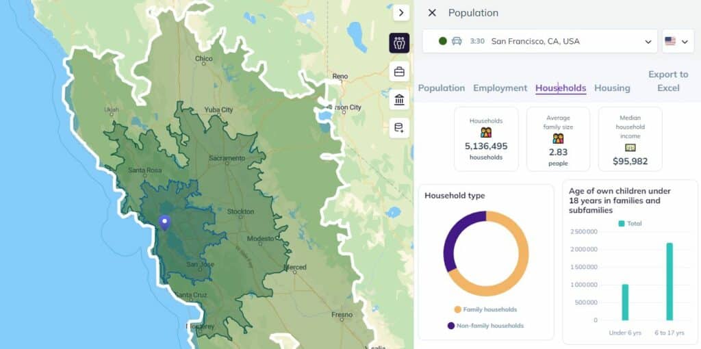
The final step is presenting the data in a way that’s easy to understand. This usually involves creating maps, charts, or other visualizations that highlight key findings. Data visualization is crucial because it allows stakeholders to quickly grasp complex information. For example, a real estate developer might use heat maps to show property value trends across different neighborhoods. You can use GIS software like the ArcGIS family of software or Smappen to make your data visually reveal its secrets.
And there you have it! These three steps will cover most instances of spatial analysis.
6 examples of spatial analysis
Now that you know the basic process behind spatial analysis, let’s look at some of the fields where it gets used.
Epidemiology
This field, which we’ve all become a bit too familiar with in recent years, studies the spread of diseases — when they go from just localized events to broader epidemics. Spatial analysis can be used to track the evolution of an epidemic, map out quarantine zones, and track the source of an outbreak.
Urban planning
Urban planners often use spatial analysis in their projects. They can use geographical data to plan deforestation initiatives, evaluate the spread of a contaminant in water lines, or chart population concentration in cities, for example.
Agriculture
For farmers and other agricultural specialists, spatial analysis is crucial for ensuring a high yield come harvest season. They can use this to monitor the health of their crops, track livestock, analyze soil health, and more.
Astronomy
Not surprising, right? After all, the root of the word “spatial” is “space,” and astronomers deal with a whole lot of it. Spatial analysis is crucial for studying the movements of galaxies and other celestial bodies throughout the universe.
History
If you thought historians only cared about dates, you’d be wrong. Spatial analysis can be used to glean all sorts of insights about our past, from how the bubonic plague spread throughout Europe to just how much territory the Romans conquered.
Business
Spatial analysis is used in a variety of business applications to solve real-world problems. Here are a few examples:
Retail: Retailers use spatial analysis to determine the best locations for new stores, analyze customer demographics, and optimize inventory management.
Logistics: Delivery companies use spatial data to plan efficient routes, reduce transportation costs, and improve delivery times.
Real Estate: Real estate firms use GIS data to evaluate property values, assess market trends, and identify potential development sites.
Marketing: Marketers leverage geographic data to target advertising campaigns, understand regional consumer behavior, and optimize market penetration strategies.
Utilities: Utility companies analyze spatial data to manage infrastructure, predict service demand, and plan maintenance schedules.
How spatial analysis is used by businesses
Spatial analysis isn’t just a great tool for scientists and urban planners; it’s great for businesses too! It helps them adjust their business strategy, plan location-based tactics, and more. Here’s how.
Business strategy
For brick-and-mortar businesses that rely heavily on local customers, it’s important to know as much as you can about them. With spatial analysis, businesses can use customer data to determine where their customers are, learn more about where they live and shop, and adjust their business efforts accordingly.
Franchising
Location data is crucial for franchises. Without it, they might open a new location too close to an older one, accidentally cannibalizing their own business! With spatial analysis, businesses can better map their coverage area, pick locations that have a bigger addressable market, and more.
Location-based marketing
This kind of marketing uses a prospect’s location to drive marketing efforts. That can mean everything from personalizing ads for specific locations to sending special offers when a prospect enters a competitor’s trade area. With spatial analysis, marketers can determine where these efforts would be most successful.
Give them some space
Spatial analysis is a powerful method for understanding and solving complex business problems. By collecting, processing, and presenting geographic data, businesses can uncover patterns, predict outcomes, and make better decisions. While it’s used in all sorts of fields, from astronomy to urban planning and epidemiology, businesses and franchises use spatial analysis to tailor their strategies and learn more about their customers. Whether it’s through spatial models, data visualization, or GIS tools, spatial analysis is key to modern business strategy.
Although this practice can seem daunting on the surface, the right app can make this process much easier. And if you use Smappen, you can get started for free right now and map out your areas!