TL;DR – Key Insights in a Nutshell
- Smappen makes territory mapping dead simple with radius, heat, and drive-time maps that help you understand where your market lives—and breathes.
- Visual data isn’t just pretty—it’s powerful. Mapping helps you spot opportunities, plan expansions, and boost local strategies with real context.
- Market demographics and smart territories = growth. Smappen blends intuitive tools with built-in data so you can strategize like a pro, no GIS degree required.
Why Sales Territory Visualization Matters
Visualizing sales territories and market demographics doesn’t just tidy things up—it uncovers patterns you didn’t even know existed. Understanding where your customers are and how they move is crucial!
Let’s break it down: good territory visualization helps you:
- Avoid overlap (a.k.a. “salespeople turf wars”)
- Spot goldmines (those high-potential areas no one’s touched)
- Match reps to the right zones (yes, efficiency matters)
- Predict market performance before you even step in
And Smappen? It gives you the paintbrushes to do just that—without getting tangled in technical weeds.
Smappen 101: What Can You Actually Do?
Smappen isn’t your average, clunky GIS tool. It’s sleek, snappy, and surprisingly simple. It lets you:
- Draw radius maps to see who’s within 5, 10, or 50 kilometers of your business
- Build drive-time maps that reflect real-world roads and conditions (because nobody drives “as the crow flies”)
- Access all the data for your zones (socio-demographic data, company data and points of interest, import of your own data, etc.)
- Create heatmaps using built-in demographic data—population density, income levels, age brackets, and more
All this, right from your browser, with just a few clicks!
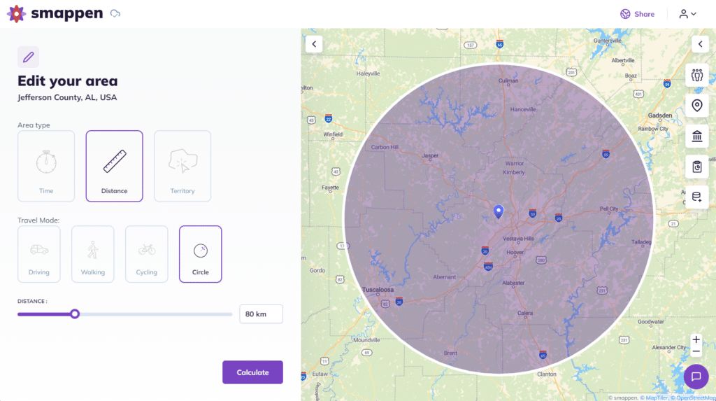
Radius Maps – The Quick-and-Clean Territory Outline
Let’s start with the basics. Radius maps are exactly what they sound like: you draw a perfect circle around a point (say, your store), and boom—you see who falls within that zone.
This is perfect when:
- You’re gauging general reach
- Setting delivery or service zones
- Allocating leads evenly among reps
But fair warning: radius maps don’t consider roads, traffic, or terrain. They’re best for ballpark analysis, not laser-precision planning.
💡 Pro tip: Use radius maps as your “first draft,” then switch to drive-time maps for serious strategy.
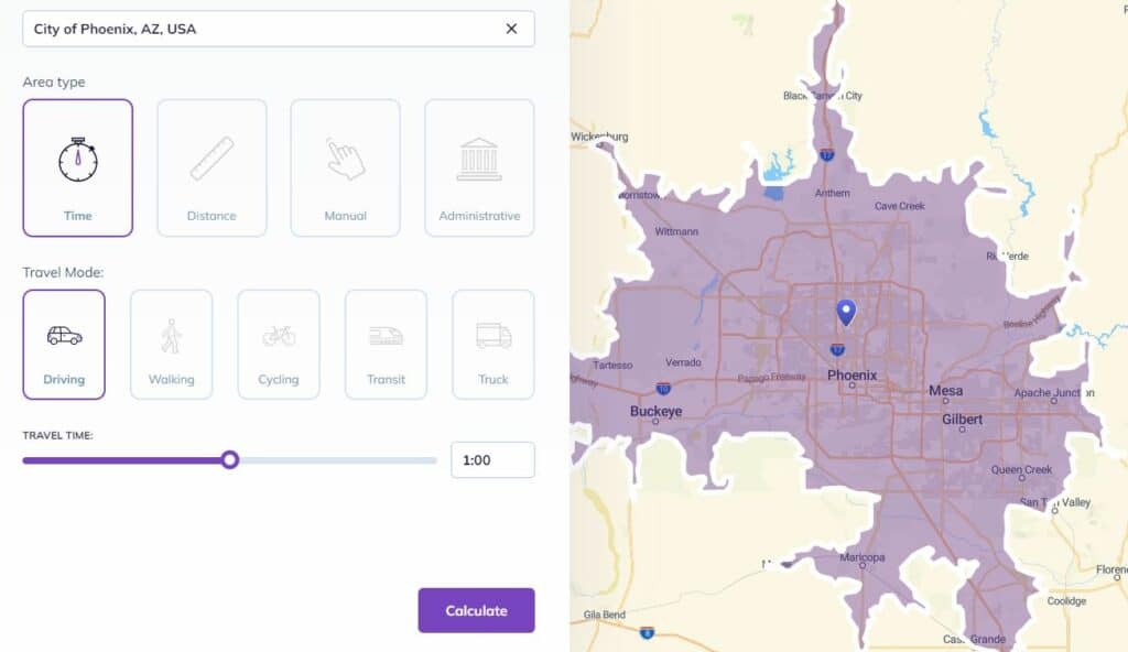
Drive-Time Maps – Where the Real Magic Happens
Now we’re talking power moves. Drive-time maps factor in real-world logistics: speed limits, traffic flow, road types. They show you exactly how far someone can travel in, say, 10, 20, or 30 minutes.
Why is this huge?
Because drive-time defines reality. A 10-minute drive in downtown Lyon? Not the same as 10 minutes in a rural village. Smappen’s drive-time maps adjust to those nuances, giving you laser-sharp insights into real customer accessibility.
Use cases?
- Planning new branch locations
- Optimizing delivery areas
- Franchising with non-overlapping territories
- Deciding where your next ad campaign should hit
Smappen lets you layer these drive-time zones like an onion—so you can compare multiple regions, analyze overlaps, and get a bird’s eye view of how your business moves.
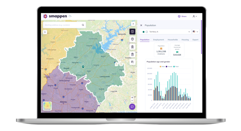
Access Market Demographics Insights
But it doesn’t stop there. Smappen also gives you access to socio-demographic data for every area you map. That means you can see things like population size, age distribution, income levels, and more — all within your defined zones. These insights help you better understand who lives in an area, so you can fine-tune your marketing, tailor your services, and make sure you’re reaching the right audience.
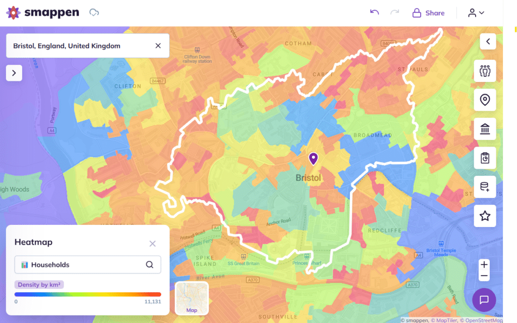
Heatmaps – The Who and Where of Your Market
Time to add the people. Heatmaps let you visualize market demographics—where people live, how much they earn, how old they are, and more. With Smappen, it’s built-in and effortless.
Why use heatmaps?
Because not every zone is created equal. You might have a 15-minute drive area with low population—and a 10-minute one that’s buzzing with potential.
Heatmaps help you:
- Identify underserved areas with demand
- Match product offers to demographics
- Prioritize high-income or high-density zones
- Build data-backed sales pitches (goodbye gut feelings)
With Smappen, this isn’t just a pretty picture. It’s an interactive map you can edit, tweak, and turn into action.
Combining Methods: Your Visual Toolkit for Smarter Strategy
Here’s where things get spicy. The real power comes when you combine these visual methods.
Picture this:
You start with a radius map to sketch initial reach. You overlay a drive-time map to refine it based on travel conditions. Then you add a heatmap layer to see which areas are actually worth your time.
Voilà: you’ve just created a custom, high-precision sales territory.
And Smappen lets you do all this on one screen. Want to draw additional custom zones? Drag, drop, and adjust. Want to compare two territories? Done in a click.
Who’s Winning with Smappen?
Retail Chains: Use Smappen to scout new store locations based on population and driving access.
📍 Franchisors: Define exclusive territories with fair drive-time coverage and zero overlap.
📍 Sales Managers: Allocate reps to areas based on customer density and real travel logistics.
>> How to optimize every deals with sales territory mapping
📍 Local Services: Optimize delivery and appointment scheduling to stay efficient and profitable.
📍 Marketing Teams: Pinpoint where your audience lives and launch campaigns where they’ll actually convert.
Beyond maps, Smappen serves up:
- Real-time updates – change an area, watch the data adjust instantly
- Data import/export – bring your own customer or sales data for a richer view
- Unlimited maps (even on the free plan) – go wild!
- Easy collaboration – share maps with your team or clients
All in a platform so easy your dog could probably use it. (Okay, maybe not—but you get the point.)
Getting Started: From Curious to Cartographer in Minutes
- Head to smappen.com/app
- Drop a pin on your location
- Choose “drive time” or “radius”
- Set your parameters
- Add heatmap data (optional but awesome)
- Adjust, compare, share—it’s all there
No install. No credit card. Just straight-up mapping magic.
Conclusion: Map Smarter. Sell Better. Grow Faster.
When you understand where your customers come from and where your competitors are, you can make smarter, faster decisions.
See clearly where to go, who to target, and how to do it better than your competitors with Smappen. It’s right at your fingertips.
And it’s not (just) us saying it :
👉 Start mapping for free today and give your business the strategic clarity it deserves.
Frequently Asked Questions (FAQs)
Absolutely. You can create, edit, and compare different areas simultaneously on one map.
Yes! It’s designed for non-technical users. You’ll be mapping like a pro within minutes.
It’s a way to see which areas people can reach your business from within a certain time. It’s great for planning store locations, deliveries, or campaigns.
Yes! By combining drive-time and competitor data, you can spot areas with great customer access and low competition.
You sure can — customer lists, sales numbers, store info — all of it can be layered onto your maps.