
Draw a radius map for free with smappen. Create as-the-crow-flies or isodistance areas in minutes for any distance or transportation method.
What is a radius map?
A radius map creates a circular area from a starting location and a specific distance (the radius).. You can set your starting location using a specific address or coordinates, then use a radius map tool like smappen to draw out the area for you. You could also do it manually with a map and a pen, but that’ll definitely take longer.
What are radius maps used for?
You could use a radius map for just about anything, from seeing all the restaurants within walking distance of a specific address to planning a construction project — say if you wanted to see how far the noise will travel. Radius maps are often used in business strategy and marketing. Businesses often use them to ensure that coverage areas don’t overlap between multiple locations, while marketers use them to plan local marketing initiatives.
How to create a radius map?
While you could do this manually with a map and some pens, creating a radius map is a lot easier with a tool like smappen. All you need to do is open the app, set your initial location, choose your distance, and hit calculate.
What is the best software for drawing a radius map?
That depends on what you need. If you want a barebones radius map, you can use a simple radius calculator. But what if you need something a little more advanced?
That’s when you use Smappen.
With Smappen, you can create radius maps in a few different ways:
- Isochrone maps: These maps show the area you can reach by travelling for a set amount of time with a specific mode of transportation.
- Isodistance maps: A bit different, these maps show the area you can travel with a specific mode of transportation if you only go for a specified distance.
- Simple radius maps: Yes, just like with radius calculators, you can use smappen to draw a simple circle over a map based on distance or time.
- Zip code maps: These maps draw out the radius covered by a chosen zip code on a map.
- Manual maps: Using a lasso tool, you can draw a circle on a map and know exactly what radius it is.
With these tools, Smappen can help you draw out catchment areas, access demographic and population data within a specific radius map, perform local market research, manage local marketing strategies, optimize e-commerce logistics, find the best location for a new branch, and a whole lot more. All with a radius map.
How to do map a radius around an address
The smappen app is the best way to draw a radius map around an address. To start, just open the app and enter an address. Then, select the Distance mode, put your chosen distance and click on “Circle” mode. Click on “Calculate,” and smappen will automatically calculate and draw a radius map around the specified address.
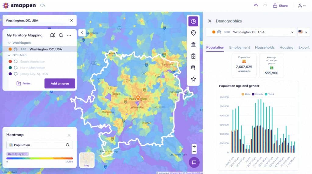
What is the difference between a radius map and a heat map?
The biggest difference between a radius map and a heat map is in the type of data they show. A basic radius map generally works with a single type of data, usually reflecting distance or travel time. By contrast, a heat map gives you color-coded data based on magnitude. So, for example, a heat map tracking temperature in a geographical location will be red where the temperature is highest and blue where it’s coldest, with a range of colors in-between. Since both maps are pretty different, they each have their own uses.
Can I generate a radius map based on driving time or distance?
Absolutely! With a tool like Smappen, you can generate a radius map that quickly communicates a radius based on driving time or distance. This can be used by companies that need to calculate their delivery radius, coverage areas, and more.
How does the radius size on a radius map impact the results?
That really depends on what you’re trying to show with your radius map. Some will be used to show demographic data while others may show points of interest like hospitals, specific stores, or schools. As the radius size grows, you’ll get more results. With some tools, however, the level of data you get will decrease as the radius increases.
Can I combine multiple radius maps on a single map to create a more comprehensive analysis?
You can definitely combine multiple radius maps in a single map. It’s a great way to compare potential coverage areas, estimate the distance you’d have to drive to reach multiple points of interest, or even dive into some deep market research. With Smappen, you can add an unlimited amount of radius maps in a single analysis, giving you a ton of data to work with.
How can I customize the appearance of a radius map?
That depends on the tool you’re using! If you use smappen to draw your radius map, you can easily edit the color of each area you create. This can be useful for comparing travel times, coverage areas, and more.
Can I use a radius map to determine the number of people in a specific area?
Absolutely! Since radius maps are often used by businesses when performing market research, they’ll usually need access to demographic data. Specialized radius map tools like Smappen can show you how many people live in a specific area, give you a rundown of local businesses and services, and even list zip codes in your radius map.
How can I share my radius map with others?
Any radius map app worth its salt will have some way to share your maps with your colleagues. In Smappen, for instance, there’s a share button in the top right corner of the screen. You can share a radius map through a link or even embed it on your website.
What exactly is a radius map?
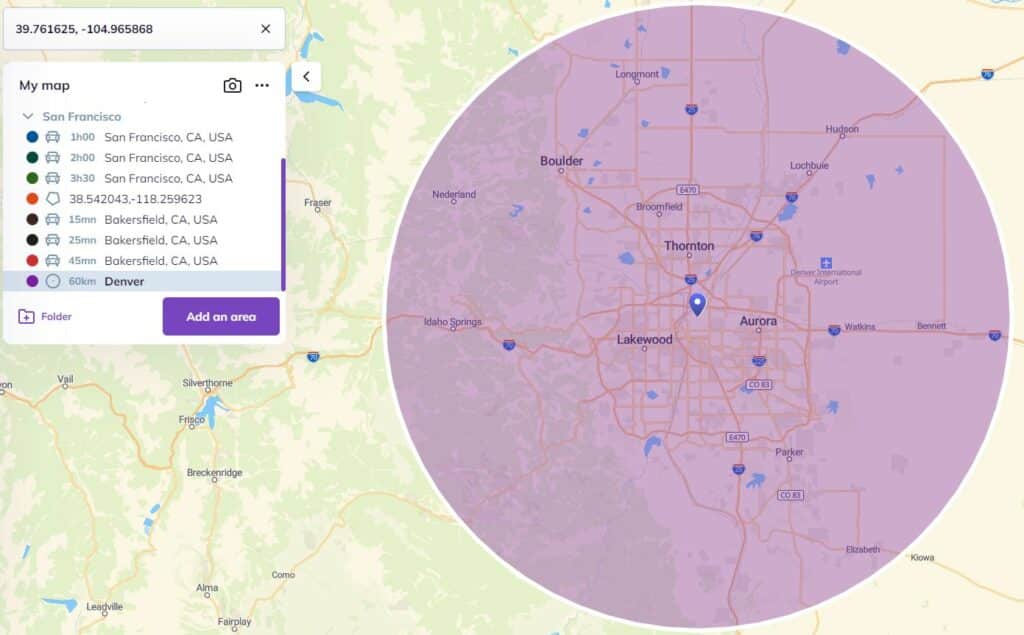
A radius map is simply a circle drawn around a specific point — like an address — using a chosen distance. Everything inside that circle is considered “within range.” With Smappen, you can create radius maps based on straight-line distance or adjust the radius depending on the mode of transport.
How to create a radius map?
Typically you choose a central location (address or coordinate), select a radius (distance) or travel-time (isochrones), then draw the area on a map tool. With your site you could emphasise:
Select “Add an area” → 2. Enter the starting point address → 3. Choose distance or travel time → 4. Choose circle mode (or isodistance/isochrone) → 5. Click calculate. (As your page already states.)
When should I use a radius map instead of a drive-time map?
Radius maps are perfect when you need something quick and simple: estimating a basic trade area, sending a local marketing campaign, or getting a first sense of what’s around.
But because they don’t account for real roads, traffic, or natural barriers, they’re less precise than drive-time (isochrone) maps. If you care about actual accessibility, drive-time maps are the better choice.
Can I combine multiple radius maps or mix them with other zone types?
Absolutely. Smappen lets you:
Create several radius maps at once
Overlay them
Combine them with drive-time areas, ZIP code layers, or custom polygons
This is super useful for sales territory planning and franchise expansion.
Can I export data from a radius map?
Yes — Smappen lets you export population data, POIs, business lists, and your mapped zones so you can use them in your CRM, spreadsheets, or reporting tools.
With Smappen, you can draw radius map and another types of maps for free.