TL;DR - Franchise Territory Mapping
As a franchisor, defining precise, data‑driven territories is critical to fair growth and franchisee satisfaction — this is where a tool like Smappen comes into play.
Smappen enables you to draw territories based on drive time, radius, ZIP/postcode boundaries, import your own data and export clear territory definitions for franchise agreements.
By leveraging mapping + demographic + points‑of‑interest data, you can minimize overlap, avoid white space, optimize for growth and present strong offers to potential franchisees.
Why Franchise Territory Mapping Matters
You’re a franchisor, you’re not just selling one store — you’re building a network. That means you need territories that are fair, strategic and scalable. Without proper territory mapping, you risk giving two franchisees overlapping potential (ouch), leaving large gaps of un‑serviced market (double‑ouch) or worse, damaging brand performance because one unit’s starved for customers.
Mapping territories means getting clear geographic boundaries (and underlying data) around who gets what, where, and why. According to Smappen, territory mapping is “the strategic process of dividing geographic areas … such as assigning … franchise locations.”
For you, that means fewer headaches, happier franchisees, smoother growth — and yes, more leads into your franchise development pipeline because you can credibly show territory potential.
The Big Challenges Franchisors Face (and How Franchise Territory Mapping Fixes Them)
Overlap & internal competition
When territories aren’t defined clearly, you might find franchisees chasing the same customers, or worse, cannibalizing each other.
With Smappen you can draw territories and detect overlaps/gaps — one of their core features.
Unequal potential & unfair structure
If one territory has 100,000 residents/households and the next has only 10,000, you’re setting one franchisee up for success and the other for struggle — not good for morale or growth.
Smappen lets you overlay demographics (population, income, age, employment) so you can balance territories.
Slow growth & guesswork
Expanding a franchise network by gut‑feeling is risky. Without data you might waste time and money opening in poor locations. Smappen helps you visualize market data, find “white space,” and make informed decisions.
Confusing sales pitch to franchisees
When you’re trying to sell territories, franchisee prospects ask: “What’s my area? What’s the potential? What’s the competition?”
If you don’t have clear answers, you lose trust and deals. Smappen gives you exportable territory reports, ZIP/postcode lists, and clean visuals for your pitch.
How Smappen Works for Franchise Territory Mapping
Let’s walk through the journey of how you’d use Smappen to build and manage franchise territories.
Step 1: Define your territory logic
Decide how you want to divide your market: by radius, by drive‐time, by administrative boundaries (ZIP/postcode/state) or a combination.
Smappen offers: radius/iso‑distance, drive‐time (isochrones), and administrative boundaries.
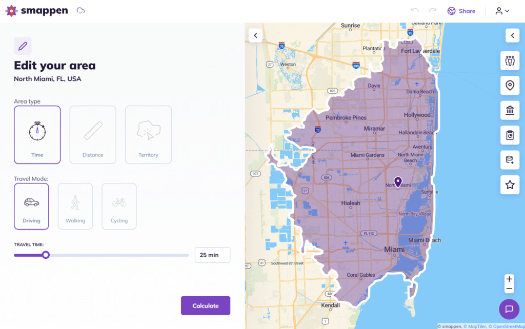
Step 2: Create your territories
In Smappen you can: add an area → choose your mode (radius, drive time, ZIP region) → draw the area.
Importantly, for franchise use: you can export ZIP/postcode lists from each area to include in franchise agreements.
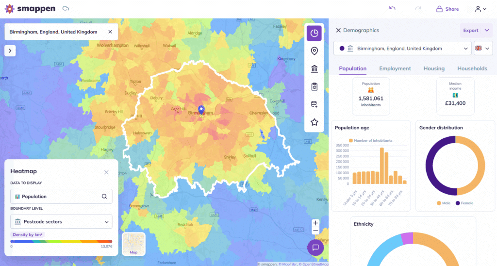
Step 3: Layer in data
Once the zones are drawn, overlay data:
Demographics (population, income, age)
Points of interest (existing competition, complementary services)
- Your own customer/lead data or CRM data
This layering turns a simple shape into a territory with insight.
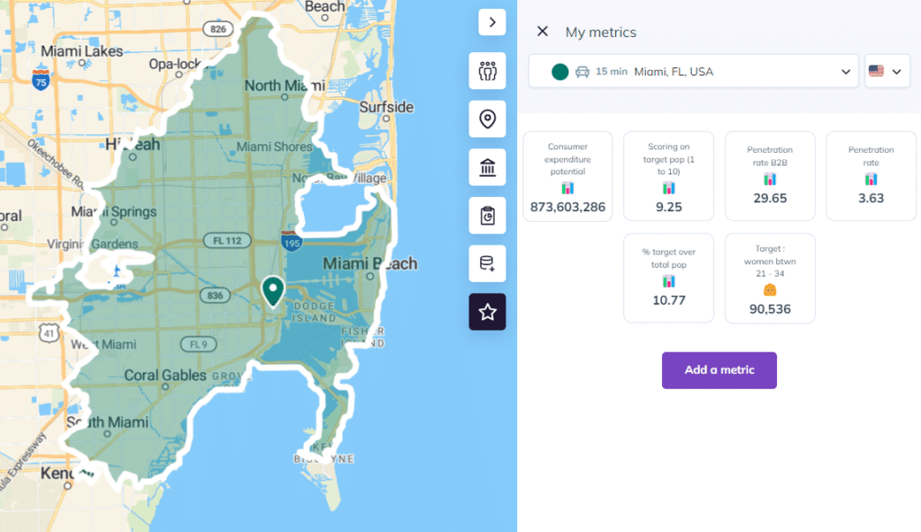
Step 4: Analyze & optimize
Check for overlaps/gaps, compare territories to ensure fairness, evaluate potential. Smappen’s built to let you see territory balance and market potential at a glance.
Step 5: Prepare franchisee‑ready assets
Export the territory definitions, ZIP/postcode lists, maps and reports. Use these in your franchise info pack or lead‑generation materials so prospects take you seriously.
Step 6: Monitor & adjust
Territories aren’t “set and forget.” As markets evolve, new data comes in, or you expand, you’ll want to revisit and adjust. Smappen supports modification, merging, extending or shrinking areas.
Key Features that Make Smappen Franchise territory Mapping ‑ Friendly
Here are some features that particularly benefit franchisors:
Drive‑time and Radius mapping– capture what “reachable in X minutes” really means, not just “as the crow flies.”
Administrative Boundary creation – draw territories using ZIPs/postcodes/states/communes depending on country.
Demographic and Points of Interest overlays – deep insight into territory composition and competition.
- Exportable data (ZIP/postcode lists, reports) – ideal for inclusion in franchise documents.
Your own data imports: for example, import a CSV or HubSpot CRM data to map your customers or leads
Custom metrics & reports: you can generate custom metrics combining demographics, imported data or business indicators, then export reports (Word, Excel, KML)
- User‑friendly interface for non‑GIS users – you don’t need to be a mapping expert.
- Global data access & competitive edge – Smappen points out it provides global data without extra country‐packages unlike some competitors.
How this Drives Leads & Traffic for Your Franchise Development
You might be thinking: “Okay, I get the territory‐mapping benefits, but how does this bring me leads” Good question.
Stronger franchise sales pitch: With clear territory visuals, data‑backed potential and exportable materials, you look more professional and credible. More credible means more leads.
Best Practices for Defining Franchise Territories
Here’s a practical checklist (informed by Smappen’s content) to get your territory design right:
- Start early – Define territories before signing franchisees; don’t wait until the network grows chaotic.
- Choose the right boundary logic – Radius may work for simple cases; drive‑time is more realistic; administrative boundaries enable legal clarity.
- Use data, not just maps – Overlay demographics (population, income) and POI (existing franchisees, competition) before finalising.
- Balance territories – Ensure each franchisee has comparable opportunity; avoid “easy” vs “hard” zones.
- Document clearly – Export ZIP/postcode lists, maps and include them in your franchise agreement for transparency.
- Monitor and adjust – Markets shift; revisit territories and adjust if needed.
- Communicate with stakeholders – Make sure franchisees understand the logic behind territories; transparency builds trust.
From customers, with love
Explore real use cases and get inspired by our customer stories to know what you can achieve easily with Smappen.
Common Mistakes to Avoid with Franchise Territory Mapping
- Using only radius maps – While easy, they ignore real travel conditions, so potential may be mis‑estimated. Smappen warns about this.
- Ignoring competitive or POI data – Without mapping what’s already in the zone (competitors, saturated markets), you risk over‑allocating territories.
- Lack of documentation – If territories aren’t firmly defined, you’ll get conflicts later.
- Not revisiting territories – Markets change. A perfect territory now may be weak in 3‑5 years if population growth shifts.
- Not leveraging the tool’s full power – Importing your own CRM or leads, extracting ZIP code lists and generating reports adds value; if you skip this, you may just have pretty maps.
Ready to Map Smarter?
No matter where your team is — or where you’re expanding — Smappen helps you map smarter, faster, and with more impact.
Summary: Why This Could Be a Game‑Changer for Your Franchise Territory Mapping
By using a robust tool like Smappen, you elevate your franchise development from guess‑work to strategic precision. That means: stronger franchisee leads, smoother sales, better growth, fewer conflicts and a brand network built to scale rather than patch. In short: map smarter, grow faster, win bigger.
FAQ's - Franchise Territory Mapping
What exactly is franchise territory mapping?
It’s assigning a specific geographic area (a territory) to a franchisee so nobody else from your brand encroaches on that zone (or you avoid unfair competition). The area can be defined by ZIP/postcode, drive‑time, radius, municipal boundaries, etc
How does Smappen make territory mapping easier for franchisors?
Smappen offers an intuitive web interface (no GIS expertise required), allows you to draw territories (radius, drive‑time, administrative), overlay demographic/POI data, export lists/reports, and produce professional assets for franchisee pitches.
Can Smappen help ensure fairness in territory size and potential?
Yes. By overlaying demographic metrics such as population, income, and households, you can compare territories and ensure each franchisee gets a fair slice of the pie.
What should I avoid when mapping franchise territories?
Avoid relying purely on simple radius maps, ignoring competition or under‑served zones, failing to document boundaries in franchise agreements, and neglecting to revisit territories as markets evolve.
How can I use this mapping approach to generate more franchisee leads?
Use the maps and data as proof‑points in your franchise marketing: show prospects the value of the opportunity by way of clear territory definition.