Properly setting delivery fees can turn a loss into a profitable sale. But if you don’t have enough data about your delivery areas, this can feel like a guessing game. One way to rectify this? Mapping out your delivery areas with dedicated territory mapping software.
Here’s why — and how — this is done.
Why should you map your delivery areas?
After all, it’s just another task on your plate, so why go through the trouble at all? Here’s what properly mapped delivery areas can do for your business.
They make you more competitive
When you’re in a competitive industry, you need every potential advantage to edge out other players. By mapping out your delivery areas, you can ensure that every order is profitable while making customers feel like they’re saving money.
They help you use your fleet more efficiently
If you use your own vehicles for deliveries, you know just how expensive that can get. Sending out a single truck on an inefficient route can keep it out of the game for an entire day, meaning the rest of your fleet will be working overtime. While the consequences of this inefficiency might not be immediately apparent, they’ll add up in maintenance costs and late deliveries.
They help reduce shipping costs for customers
The more efficient your deliveries are, the less you have to charge customers for them. When you’re charging $15 for a delivery and your competitor is charging $25, that can be enough to pull customers away from them.
5 business processes that get easier with mapped delivery areas
Using territory mapping software to manage delivery ideas can help your business grow, improve your profit margin, and reduce the risks that come with any sort of delivery. Here’s why.
Managing inventory
If you have multiple warehouses and distribution centers, fulfilling every order becomes more complex. With territory mapping software, you can use various methods to map out zones with each warehouse and distribution center as the starting points — helping you determine exactly where your inventory needs to go.
Attributing sales to individual stores or sellers
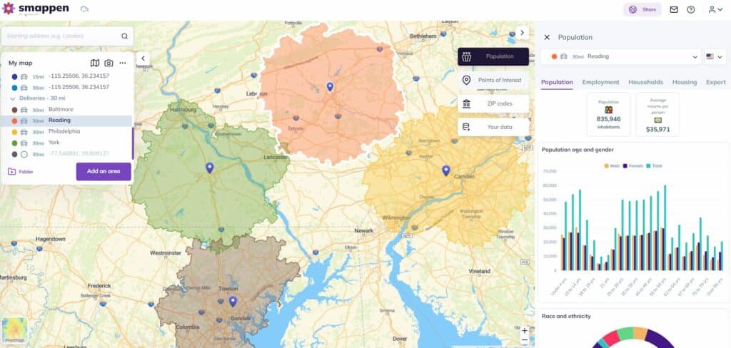
Whether you’re running a franchise or just have multiple stores, you need a method of attributing sales to each location. This kind of data can help marketers evaluate the success of their campaigns, logistics people know exactly which warehouses need more inventory, and strategists understand which areas are best for your business. With a location intelligence tool like Smappen, you can cross-reference your order data with your delivery areas to attribute sales to individual warehouses. You could even export zip codes from your delivery areas and import those into your other software tools.
Properly structuring your territories
When you have multiple locations, properly mapped delivery areas can translate to many aspects of business strategy. If you’re a franchisor, for instance, you can use a similar method to map franchise territories with greater accuracy — resulting in happier franchisees. If you have multiple locations, you can compare delivery areas to minimize dead zones between them or even prevent excessive overlap. It’s also a great way to research new locations, whether you’re moving or opening a new store.
Setting delivery fees
Your delivery fees have to strike the balance between keeping each sale profitable and not completely alienating your customer. Too expensive, and your sales will dip. Too cheap, and you’ll start losing money. By properly mapping your delivery areas, you’ll able to more accurately estimate your shipping costs, leading to better delivery fees.
Researching markets within delivery areas
When you use the right tools, a delivery area won’t just tell you how long it’ll take for a driver to reach your customer; it can be a powerful asset for market research. A tool like Smappen can pull demographic information from your delivery areas like average income, gender distribution, and other characteristics. This can help you gauge the size of your addressable market around each point in your delivery infrastructure.
How to map delivery areas
Now that you know just how much of a difference properly mapping delivery areas makes, let’s dive into how it’s done.
Pick the right method and draw your maps
Most businesses use a radius map to determine their delivery areas, which simply plops down a circle of a certain size on top of a map. While this can be done quickly — and even manually — it doesn’t reflect real-world conditions, which limits their effectiveness. Instead, use one of these two methods:
- Isochrone areas let you use drive times to map your delivery areas. Say you want your drivers’ round trips to last an average of one hour, you could create a 30-minute isochrone map in a tool like Smappen. These maps automatically account for real-world driving conditions.
- Isodistance areas work similarly, in that they reflect real driving conditions. But instead of time, they use distance. This will show you what a 10-mile delivery radius would look like when your drivers actually have to use roads and highways, which is great for estimating fuel costs and other expenses.
With these maps drawn, you’ll get a better idea of your coverage across multiple locations and can spot any dead zones that you need to fill. And if you’re researching a new location, you can use a tool with demographics and POI data — like Smappen — to get all the information you need.
Extract zip codes from each area
While drawing more accurate maps is great for market research and optimizing your logistics, extracting zip codes from these areas is essential for using them with other tools. E-commerce platforms and other fulfillment partners, for example, might allow you to automatically dispatch orders to certain locations based on a zip code.
With your maps drawn, you can then compare them to a zip code map through any number of online platforms. Or, you could do it automatically with Smappen.
Import your own data
If you already have a good amount of customer data, you can import it into a location intelligence tool to see it represented on a map. That way, you can see how spread out customers are within your delivery areas, identify those who fall in dead zones between multiple areas, and even spot opportunities for new locations.
How Everscore uses Smappen to optimize deliveries
Everscore brings the modern convenience of retail, social media, and other services to the cannabis industry — in which popular platforms like Amazon aren’t available. Everscore Founder & CEO Jeff Sampson’s mission is to turn the cannabis market into the next Uber Eats or Airbnb; a single place customers can go to and find suppliers near them. He trusts Smappen to help his organization navigate the complexities of this difficult market.
“Airbnb is in hundreds of markets. But if you’re going to Boulder, Colorado, all you’re concerned about is the inventory of available homes in Boulder, right? This is where we use Smappen, because we need to stitch together those local communities that rally around the products we’re able to offer.”
For Everscore, Smappen delivers on location intelligence, marketing research, and delivery area mapping.
Get Smappen and see it for yourself
Need a better way to map your delivery areas? Try Smappen for free.