Draw a circle with a radius on a map
Draw a radius map for free with smappen. Create as-the-crow-flies or isodistance areas in minutes for any distance or transportation method.
Whether you’re a business strategist, a marketer, or a logistics expert, radius maps can be your secret weapon for insightful decisions. Discover what radius maps are, how they’re used, and why tools like Smappen offer the most dynamic way to harness their potential. From simple circles to complex isochrone and isodistance maps, learn how to master the art of radius mapping and revolutionize your location-based strategies.
Read our best articles on radius map
The 5 Best Tools for Drawing Radius Maps
Discover what radius maps are, how they’re used, and why tools like Smappen offer the most dynamic way to harness their potential.
All you need to know about radius maps
Discover what radius maps are, how they’re used, and why tools like Smappen offer the most dynamic way to harness their potential.
Unlocking the Power of Radius Maps: Smappen's Geomarketing Solution
In today’s fast-paced business world, location-based intelligence is a key to success. Understanding the geographical reach of your business, assessing market potential, and identifying growth opportunities are crucial for any enterprise. That’s where “radius maps” come into play, and at Smappen, we’ve revolutionized the way you can harness their potential. In this blog post, we’ll explore the significance of radius maps and how Smappen’s geomarketing solution can supercharge your location-based insights.
What Are Radius Maps and Why Are They Important?
They are a fundamental radius map tool for businesses aiming to thrive in their local markets. They allow you to define a specific zone around a central point, offering invaluable insights into your target audience and potential customer base. By understanding the geographical landscape, you can make informed decisions about marketing, expansion, and resource allocation.
Can you do a radius on Google Maps?
Google Maps does not offer the functionality to directly determine one around a location. However, it does allow you to measure the distance or drive time between two or more points.
Smappen's Innovative Approach to Radius Mapping
At Smappen, we’ve taken radius mapping to the next level. Our geomarketing solution empowers you to create maps, manage, and visualize catchment areas with unmatched precision and ease. Our mapping tool multiple modes of defining it, including isochrones, isodistance, manual drawing, and administrative boundaries. This flexibility ensures that you have the perfect software to analyze your business’s local appeal and reach.
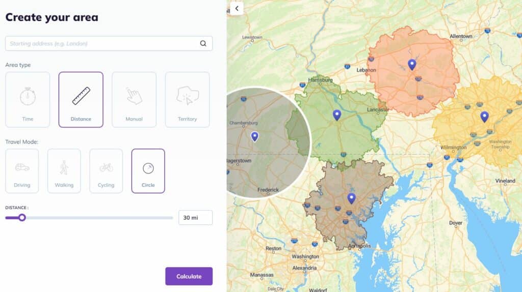
How to Create Radius Map Effectively
With Smappen, creating a radius map has never been so easy!
- Go to smappen.com/app/ (it’s free)
- Click on “Add an area”
- Define your starting point address
- Select the “travel-distance” mode
- Then, click on “as-the-crow-flies” mode
- And select the distance you need (in miles or kilometers)
- Click on Calculate
And there you go! You have your radius on a map, in less than 1 minute 🙂
With Smappen, you have a bunch of choice to draw your areas: by distance, by time, and also by states, counties or zip codes. >> Creating one
What is the best map radius tool?
Radius calculators provide a clear visual representation, which helps in understanding the zone covered. They are generally user-friendly, requiring minimal technical knowledge and are available online and can be accessed from any device.
Here are some of the best ones:
Smappen is highly regarded as an overall tool. It enables users to draw multiple drive time and radius maps quickly, overlay them, and cross-reference them with a wealth of data for purposes like market research and logistics optimization. Smappen comes equipped with points of interest, demographic data, and even competitive insights, making it an ideal choice for marketers, franchisers, retailers, and others who need to use it for in-depth research.
Maptive is an enterprise-level GIS software that integrates Google Maps data with radius mapping. It allows for the creation of customizable radius maps, route optimization, heatmap generation, and the addition of up to 100,000 locations when you create a map. Users can color-code individual pins, use branded images, and personalize their base maps, making Maptive one of the most customizable tools available.
CalcMaps is a completely free online suite that helps with calculating areas, elevation, and drawing radius. The process of creating a radius map with CalcMaps is straightforward: simply choose an address, specify a distance, and you instantly have it, along with the zone of the drawn circle. This simplicity and no-cost aspect make CalcMaps an attractive option for basic radius map creation.
Free Map Tools offers a range of free mapping tools, including those for calculating distances and drawing radius maps. The process is user-friendly: place a pin on the map, draw your circle, and the exact radius of the zone is provided. There is also an option to export it with coordinates for use in other ones. This one is convenient for those who need a quick and easy solution for radius mapping without additional data layers.
TravelTime is distinguished by its ability to create isochrone maps (showing how far you can travel in a specific amount of time), TravelTime is particularly beneficial for establishing delivery ranges, identifying coverage areas, and choosing locations for franchises. Unlike mapping tools that only allow simple radius based on distance, TravelTime’s maps account for terrain and travel times, which can be layered for comparative analysis.
Each of these offers different functionalities, catering to various needs from basic mapping to advanced data integration and analysis. Your choice will depend on the specific requirements of the task at hand, such as the level of detail needed, the type of data integration required, and whether the radius calculator needs to be free or can be a paid service.
Unlocking Demographic Insights within Catchment Areas
One of Smappen’s standout features is the ability to access demographic data within your catchment areas. With our data, you can gain insights into the population’s gender, age, socioeconomic status, housing, and more. This information is invaluable for tailoring your marketing strategies and understanding the local consumer landscape. By utilizing Smappen’s robust demographic analysis tools, you can craft highly targeted marketing campaigns that resonate with the local population, ensuring higher engagement and conversion rates.
Competitive Analysis and Local Economic Insights
Smappen goes beyond traditional geomarketing. Our platform enables you to perform competitive analysis and gain insights into the local economic landscape. With a simple keyword search, you can identify businesses or services around, fostering collaboration opportunities and a deeper understanding of the local market dynamics. This function not only helps in identifying competitors but also in spotting market trends and potential for expansion, thereby enhancing your strategic planning and competitive edge.
Harnessing Customer Data for Growth
Looking to understand your customer base better? Smappen allows you to import your own data. This feature answers critical questions like, “Where do my customers come from?” and “In which zone do I generate the most revenue?” It’s a game-changer for improving market penetration and strategic decision-making. With this data-driven approach, you can optimize resource allocation, tailor your marketing efforts more effectively, and ultimately drive substantial business growth.
Why Choose Smappen for Your Radius Mapping Needs
What sets Smappen apart from its competitors? Our user-friendly approach, coupled with a highly responsive support team, ensures you get the most out of our geomarketing solution. Unlike others, we offer flexible pricing with a monthly subscription model and no long-term commitment, making Smappen accessible to businesses of all sizes. With minimal training requirements, you’ll be up and running in no time.
Radius Maps and Data Visualization: Tips and Tricks
When working with radius tools and data visualization, there are several tips and tricks that can greatly enhance the effectiveness and impact of your visual representations. Here are some key points to consider:
Choose the Right Radius Tool by selecting one that best fits your needs. ArcGIS, Maptive, and others offer various features for creating radius maps. Consider factors like ease of use, data integration capabilities, and customization options.
Before you start mapping, have a clear understanding of the data you are working with. Knowing what you want to visualize and why helps in choosing the right type of radius map and the appropriate visualization technique.
Avoid cluttering your map with too much information. Focus on the most important data points to make your map readable and effective. Use radius calculators to highlight key zones of interest or concern.
Colors can significantly impact the readability and interpretability of your map. Use contrasting colors for different zones to make comparisons easier. Also, be mindful of colorblind-friendly palettes to make your maps accessible to a wider audience.
If you have multiple data sets, consider layering them on your map. This can provide a more comprehensive view and allow for more complex analyses. However, ensure that the layers are distinct and easy to toggle on and off for clarity.
Radius maps and are a powerful insight for businesses seeking to thrive in their local markets. Smappen’s map tool takes radius mapping to new heights, offering a user-friendly approach, robust support, and flexible pricing. Whether you’re in the franchise industry or part of distribution networks in various sectors, Smappen empowers you to unlock the potential of location-based insights.
Position your business at the forefront of local market research with Smappen – your trusted partner in geomarketing.
Create your radius map with smappen